An annoying problem has developed with the publication schedule of the Black Range Naturalist (BRN). I sometimes receive material which is excellent but the publication schedule of the BRN does not support timely publication of the material; drafts of the next two BRN’s may be close to final for instance. I may be working on a future issue of the BRN which is nine months out. Publishing something nine months after I receive it is not timely. So I (Bob Barnes) have decided to revisit the idea of publishing a blog on the Black Range (BR) website, to address this particular problem.
This blog (“Natural History Blog”) will be focused on getting material out there for people to see and react to, rather than on providing a researched piece. It apparently will not focus on catchy blog names.
Please provide your comments directly to me at rabarnes@blackrange.org.
@@@
Hillsboro 2025 CBC & Olive Warbler
A blog by Gordon & Laurie Schremp
My wife and I have been active hikers and birders since 1998, mostly throughout California, SE Arizona, and various South America destinations. After visiting New Mexico for more than 20 years we decided to retire to Albuquerque adjacent to the Petroglyph National Monument during the summer of 2022. Having participated as team leaders on four northern California Christmas counts we wanted to continue that citizen science in our new home. The relatively new Hillsboro count allowed us to help out in a remote portion of the state with resplendent scenery and diverse high-desert ecosystems that increase the odds of sighting unusual species.
The history of the Audubon Christmas bird count dates to Christmas day, 1900, when 27 participants in 25 locations documented species and numbers sighted that day. Nearly all of those locations were east of the Mississippi River with the exceptions of Pacific Grove, CA and Pueblo, CO. An ornithologist by the name of Frank Chapman is credited with championing the switch from Christmas day bird hunting competitions to bird counting competitions. The switch caught on and has spread outside the borders of the United States to over 20 other countries. The primary purpose for these annual counts is to track the species diversity and total numbers over time to better understand changes to avifauna populations. Each count “circle” is 15 miles in diameter and participants endeavor to identify and tally all of the birds sighted, and even heard, from dawn to dusk. Some participants start even earlier or continue birding after sunset to document the presence of owls, nightbirds and other nocturnal species.
The 125th annual CBC ran from December 14 to January 5. There were 2,693 count circles spread over 21 countries. The 83,109 participants documented 2,503 species and 44,259,423 total individual birds. Take a look at the Audubon link to see which count circle is closest to your home. For a deeper dive, the Audubon Society also has links to writeups for each of the counts. The earlier publications are quite interesting.

Our third Hillsboro CBC began with a gorgeous sunrise prior to ascending Horse Thief Pass from SR 27. The SW route commenced at the intersection with Conesco Trail Road, paralleling Berrenda Creek, until reaching the old Berrenda Ranch structures. Due to the extremely dry conditions, absence of visible water, and low bird numbers viewed during the prior afternoon’s scouting mission, we anticipated less diversity and lower individual numbers than the 2024 count. Within a couple of minutes those concerns were dispelled by dozens of juncos and sparrows emerging from the riparian cover, interrupted by a Red-Naped Sapsucker. Sparrow diversity increased as we neared the old ranch with Brewer’s, Vesper, Song, Savannah, Black-throated, Sagebrush, and House (I know, it’s still a countable species) joining the party. Unfortunately, there were no thrashers or Chickadees that were encountered in 2024.
Rejoining Berrenda Road (county road B003), we headed for the Gila National Forest boundary via county road B116. Stopping at a dry mud remnant of a cattle pond in a small ravine, we were pleasantly surprised to see six Black-throated Sparrows pop up in response to my pishing. Continuing on, the road took us back down towards Berrenda Creek where we briefly halted at an old steel tank with a variety of shrubs and stunted trees. A shy, but briefly inquisitive Lincoln Sparrow made an appearance before dashing away. But we struck out on Loggerhead Shrike and Rufous-crowned Sparrow that had been picked up the previous two counts.

After recrossing the dry wash of Berrenda Creek, we approached the canyon entrance to the south of Schoolhouse Mountain. The bird activity immediately picked up with the increased cover on both sides of the riparian corridor. We exited the jeep, leaving it temporarily parked in the middle of the road since all of the land on either side of the road leading up to the entrance of Gila National Forest is private and cannot be traveled upon to avoid trespassing. Not to worry though, plenty of avifauna to be viewed on foot from the road! A mixed flock of Juncos and Sparrows (Chipping & White-crowned) was joined by a couple of Bridled Titmice, a dozen Western Bluebirds, Ruby-crowned Kinglets, Spotted Towhees, Hermit Thrush and a Hutton’s Vireo.
Always on the lookout for something out of the ordinary while out on a count, we sighted a larger warbler-like individual initially foraging in a juniper. I briefly saw some yellow and a flash of wing bars before raising my camera to try and capture some images. Within 15 seconds the bird flew off without the chance to view with my binoculars. Laurie called out from up the road and said she had a warbler in view for less than a minute. Before I even had a chance to review my photos to see if I could make an ID, a warbler alighted in a deciduous tree about 20 feet from me with the sun at my back (perfect viewing conditions). I immediately recognized its unusual plumage and briefly panicked that it would scoot before I could get a few photos. Fortunately, the individual stayed in place for at least a minute enabling me the opportunity at some quality shots. Only after it departed did I review my pictures, then walked up the road to tell Laurie that we were going to need to fill out a rare bird report for the female Olive Warbler!
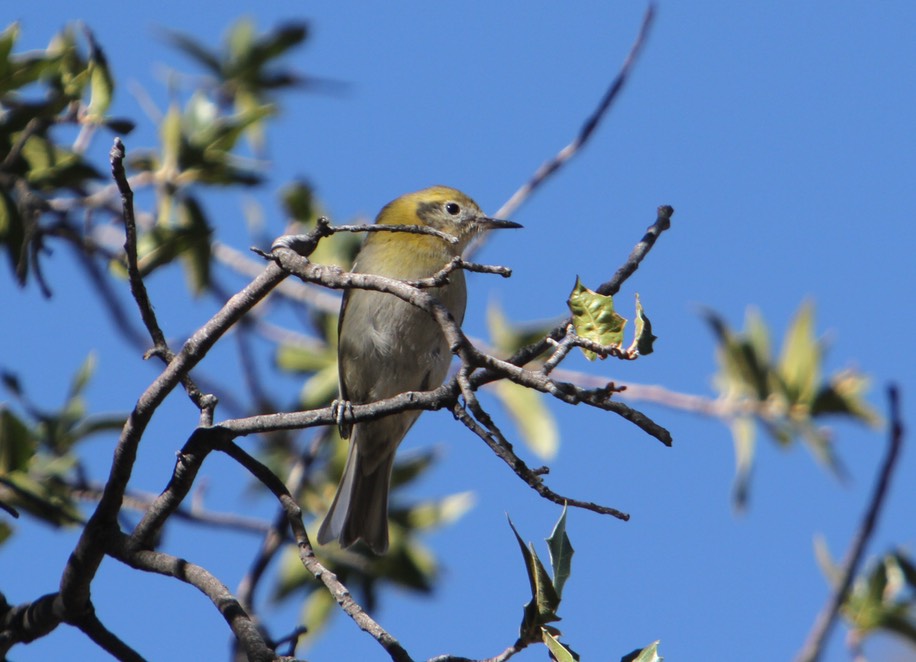
Laurie and I have seen Olive Warblers before on a half dozen occasions, mostly in SE Arizona at high elevation. For anyone else who has had a chance to view this species, the experience usually consists of a single bird at the tippy top of a pine tree at around 8 or 9 thousand feet elevation. The count view was by far the best look either of us have had to date. By the time we reached the Gila national forest boundary, we had traveled 4.8 miles and observed 36 different species.

Olive Warbler is not part of the Wood Warbler family, rather a species now considered as the sole member of the Peucedramidae family. During the breeding season Olive Warblers inhabit forested areas above 6,000 feet that contain various pine tree species that are used for nesting. According to the Sibley range map, Olive Warblers migrate out of the United States into Mexico greatly reducing the probability of a Christmas bird count encounter except in SE Arizona. So one would assume that the individual we sighted was highly unusual.

According to Cornell Labs, the majority of Olive Warblers that breed in the United States are likely to be permanent residents or migrate a very short distance usually to a lower elevation during the winter months as depicted by their range map. So how unusual was this sighting for the SW portion of the Hillsboro CBC if many of the Olive Warblers move to lower elevations in the same area to hang out in mixed flocks? One measure would be to see the relative abundance of this species during the middle of December based on weekly eBird data for the period 2009 through 2023. Each grid will show a numerical representation of how many individuals of a specific species would be viewed by an expert birder during a one-hour period over a 2-kilometer track during the peak time of day. For example, viewing the weekly abundance of Dark-eyed Junco reveals that their score would be between 6.5 and 8.5 individuals for the grid that Laurie and I were birding for the middle of December. By comparison, the abundance score for Olive Warbler at the same location and for the same day is listed as 0.00.

The location of our Olive Warbler sighting (red star) is just outside the Gila NF boundary. The closest abundance grid is approximately 3 to 4 miles to the west of our position with a rating of 0.04. That means an expert birder would have to bird that grid area 25 times to eventually sight a single Olive Warbler. This abundance resource from eBird is a very useful tool to identify locations that provide a greater probability of viewing a particular species of interest either on a specific week or throughout the year.
And now for the rest of our day…The second leg of our outing involved a 5-mile roundtrip hike from just inside the NF boundary (designated by a green gate). More of the same from the first leg with a couple of new species (male Northern Harrier & Bushtits). On our way back either over the same route or off to the other side of the canyon it is always a judgment call regarding tallying any additional individuals of species already sighted on the outbound leg of the hike. Best approach is to stay conservative and only add to the count if you encounter a group larger than previously seen, then go with that higher number. Single individuals that stay in a relative small location can be a new bird if the new location is at least half a mile or more from the original sighting.
The final leg of our journey had us retracing the roads all the way back to the old Berrenda Ranch property. Along the way we picked up a Sharp-shinned Hawk that moments before caught what appeared to be a Pink-sided Junco. Still no Shrike or Rufous-crowned Sparrow. We like to stop by the old ranch in the later afternoon to see if any additional species are present or flocks larger than encountered in the original morning stop. As such a single American Robin and 7 Red-winged Blackbirds were new for the day, along with a larger flock of Brewer Blackbirds (64) than previously sighted in the morning (26). One final new species (Say’s Phoebe) presented prior to our reaching the intersection with Horse Thief Pass Road around 4:15 PM. Final count to another splendid CBC outing was 43 species over 9 hours with 9 miles of driving and nearly 6 miles by foot. Can’t wait ‘til next year!
Harris’s Sparrow and CBC
The Harris’s Sparrow, Zonotrichia querula, which had been visiting our yard in Hillsboro for a week but decided to stop doing so last Sunday, has reappeared. Why is the timeframe of importance? Because of the annual Hillsboro Christmas Bird Count (CBC) which was conducted yesterday. CBC’s are conducted in many places in the world. How Hillsboro came to have one was discussed in the April 2020 issue of The Black Range Naturalist. Part of the CBC event is something called count week. If someone sees a bird which was not reported on count day, during the three days prior and three days after count day, then that species is recorded as appearing during “count week”. The results are not in from everyone and will not be fully tabulated for several weeks, but it appears that a Harris’s Sparrow was not seen on count day. We had not seen it during the three days prior to count day. Well, it appeared today, late for count day, but a “count week” bird.


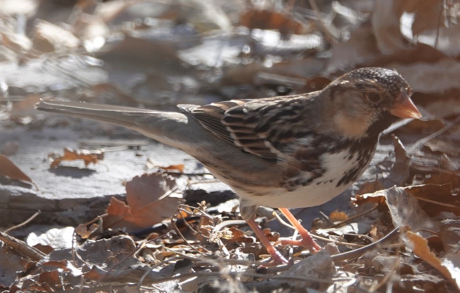
The Harris’s Sparrow is rare in our area. It is found primarily in the mid to southern Great Plains during the winter and farther north during the summer. We were seeing it here in 2017 and 2018 on a pretty regular basis, however. Then a long hiatus until mid December of this year when one reappeared. In previous years we had seen it at about this time and as late as March.
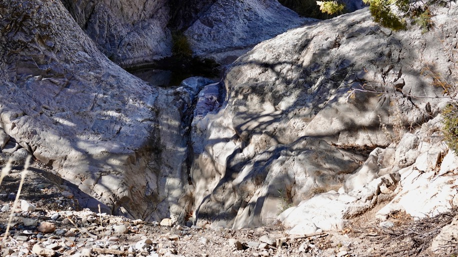
Speaking of the CBC. "How was it?” you might ask. From my perspective it was terrible, hopefully others had better luck. I suspect that it fullfilled its function, providing an indication of the bird population of a defined area (by species and number of individuals per species), very well. It is just that we appear to be in the midst of a major bird crash. The number of species and the number of individual birds being reported by knowledgeable observers is way down. It may be because we have no water. I took the photo below at the trailhead for Forest Trail 135 which is accessed via Tierra Blanca Road. There has always been water flowing over the rock at this spot. In fact, this spot made the cover of Volume 4 of Walks in the Black Range. There was a small pool but no water flowing over the rock yesterday and no birds.
“Our route” for the CBC runs from the Hillsboro cemetery south to Tierra Blanca Road and then west on Tierra Blanca to the Forest Service Road which runs north. We saw no doves yesterday. In past years we have seen hundreds of doves of multiple species on this route.
-Bob Barnes, Hillsboro
Black Range Naturalist

The January 2026 issue of the Black Range Naturalist has been posted (follow the link to read on-line or download). This issue includes the following:
- Fire
- Hunting and Gathering
- An excerpt from the book by Bob Barsch and a review by Bob Barnes
- Waterfalls of the Black Range
- Middle Percha Creek
- Carbonate Creek
- Mineral Creek
- Percha Creek
- Middle Percha Creek
- Roundville Falls
- “Falls” at Wall Lake
- Drummond Canyon
- Tall Canyon Falls (Head of Black Canyon)
- Geology and Hydrology in Real Time
- Blister Beetles - A Brief Overview
- Blister Beetles Which Might Be Found in the Black Range
- Broad-billed Hummingbird
- Explosive Seed Dispersal
- A Few More Odonata and Notes from the 2024 Field Season
- Follow-ups and Tidbits
- Decentralized Thought
- Gold
- Demon-toothed Fish
- The Massive Decline of Butterflies
- The Massive Decline of Birds
- Tiny Machine Learning Models (TinyMLs)
- Extreme Weather Events
- The Evolutionary Process
- The Evolution of Evolution
- Bat Migration
- Bat Echolocation Used To Map Long Distances
- Debris Flows
- Valley Fever and Climate Change
- Time as a Controlling Factor in Forest Carbon Storage
- North American Beaver
- Canyon Tree Frog
- Rose-breasted x Black-headed Grosbeak
- Finch - Partial Albinism
- Close Encounters With Geese
- Visual Survey Techniques
- The use of remote “bird cams” devices when conducting population surveys and documenting specific observations
- What People are Reading and Listening To
- Flammulated Owl
- Red-spotted Toad
- Mushroom
San Lorenzo Canyon, Socorro County
San Lorenzo Canyon is not in the Black Range, it is located a few miles to the northwest of Socorro. A new video of the canyon has been added to the btina.org (Birding Trips in North America) website and it is worth mentioning here.
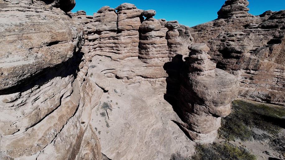
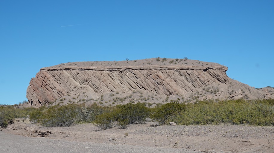
San Lorenzo Canyon is a great place to ramble and to marvel at geology. It is a relatively compact place with striking formations, narrow canyons, even more narrow slot canyons, and lots of sandstone. Most of the formations are formed from Miocene-aged rock of the Popotosa Formation. This is all part of the Rio Grande Rift.
For more on the geology of this area you may wish to read Richard Chamberlin’s report: Geologic map of the San Lorenzo Spring Quadrangle, Socorro County, New Mexico (2004). See the map for geologic unit descriptions.
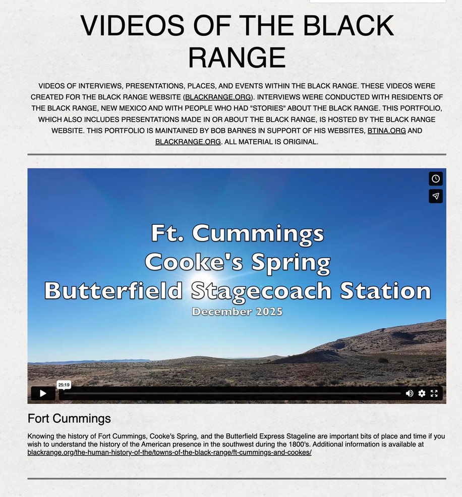
Ft. Cummings Video - 2nd Edition
In January 0f 2014 we were well into our series of road-trip videos from the Black Range. That month we published one which depicts the road from NM-26 north to Ft. Cummings, Cooke’s Spring, and the Butterfield Express Stagecoach line station. We have now updated that video to include drone video of the sites at the end of the road. (We also agressively edited the original video and added it to the end of the drone video. The project is now shorter than the original. The original can still be found in our road videos portfolio.) The new video is part of our portfolio of Videos of the Black Range and can be found at Ft. Cummings.
While more focused on human history specifically, the video does provide an overview of the natural history of the area including vegetation patterns and topography.
Continuing Drought
Our drought continues. Nothing new about that. We have addressed the issues associated with the continuing drought in the pages of The Black Range Naturalist on several occasions. But when our “normal” water is so little, less than little can be catastrophic.
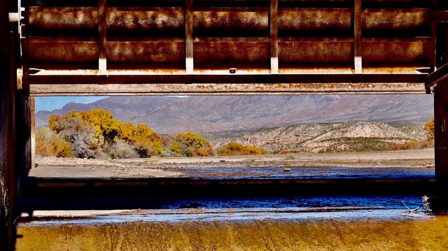
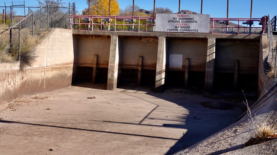
The flow in the Rio Grande is about normal for this time of year, because it is a dam controlled water feature. The photos below were taken at Percha Dam in late November, they show what our normal is at this time of year. The first image is taken looking up river through the gates of Percha Dam.
Aztec Dancer Addendum
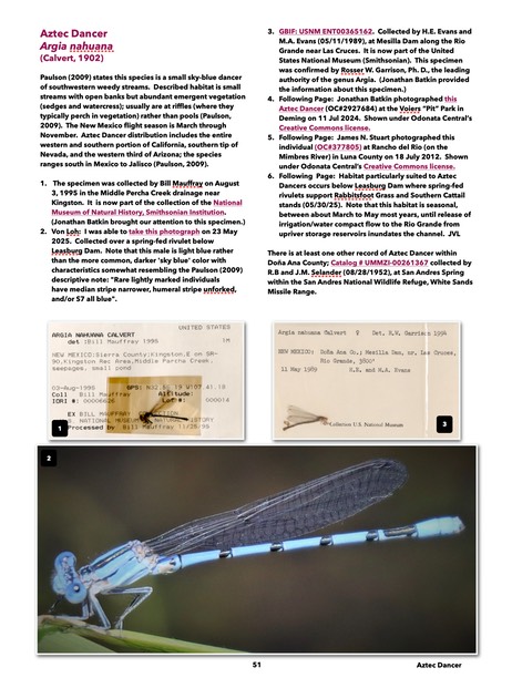
Jim Von Loh's time in the field during the last few months continues to yield positive results for us. His efforts at Leasburg Dam State Park near Radium Springs have yielded an expanded species account for Aztec Dancer. It has been published on our Odonata page as Addendum 3 to Volume 2, of the Second Edition of The Odonata of Doña Ana County and the Black Range - The Damselflies.
Locating and photographing such small creatures is a labor of love, a substantial labor of love. We get the benefit of Jim’s efforts.
Enjoy
Cracks In The Mud

Sometimes I am amazed at the things which amaze me. Take these cracks in the mud, for instance. I found them along the Rio Grande above Caballo Dam eight days ago. I spent fifteen minutes or so just staring at them. Some of the large cracks were vertical cuts of four to five inches. These cracks extended over a very large area.
I was, and am, at a loss to explain how vertical cracks at that depth can develop. To a knowlegeable person there is probably an obvious explanation. But I am not knowledgeable so I get to be unabashedly amazed. - RABarnes
Vivid Dancer
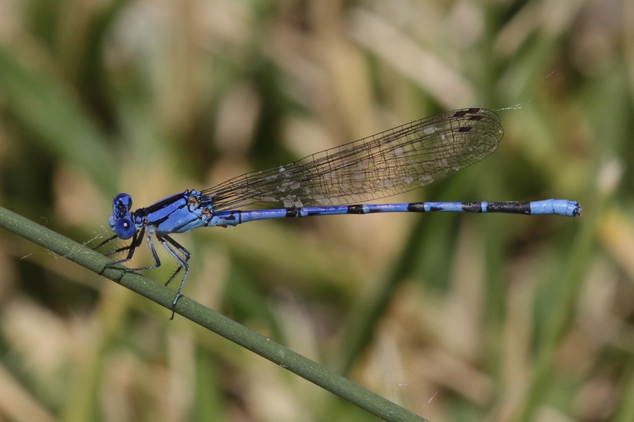

Two addendums have been added to the Second Edition of The Odonata of Doña Ana County and the Black Range - The Damselflies. Both deal with the Vivid Dancer, Argia vivida. Based on the extensive research of Jonathan Batkin we have added this species to our survey. In his assessment of observations of this species from southern New Mexico he discovered two specimens of this species collected in the Black Range in 1978.

It is very difficult (impossible in many [perhaps all] cases) to distinguish this species from Springwater Dancer, which is found in our area, using photographs like those depicted on iNaturalist. So care should be taken in identifying a specimen as Vivid Dancer in our area. Given that “disjunct” individuals were captured in the Black Range in the late 1970s it is important that we be aware of the possibility that Vivid Dancer could be found here.
If you identify a Springwater/Vivid Dancer in our area which you believe may be a Vivid Dancer please let me know and provide any informatin you can about the observation, including location and photographs and I will alert Batkin to the observation. (Thank you, rabarnes@blackrange.org.)
The photograph of a verified specimen, shown above, from the northern part of the state, was taken by Jonathan Batkin near Aztec.
The first addendum is the species account which will be added to future versions/editions of the survey. The second addendum is a summary of the research performed by Batkin. We will publish that addendum as an article in the April 2026 issue of The Black Range Naturalist.
Wilson's Snipe

Wilson’s Snipe, Gallinago delicata
Photographs above and below were taken on
November 23, 2025 at the Caballo Dam Campground
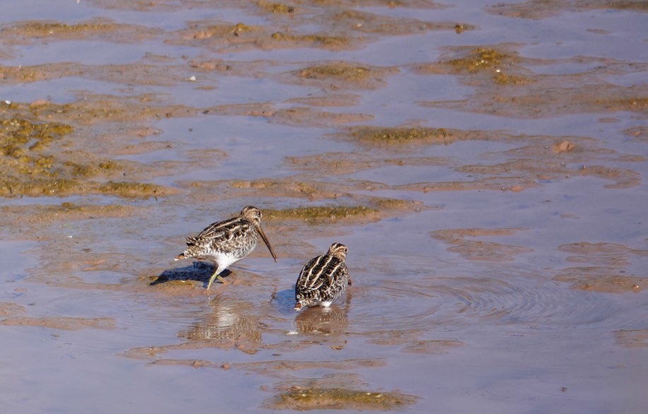
The Hillsboro birding group found Wilson’s Snipe at Caballo Dam during their monthly outing on November 23. Rather unusual to find this wader at this site.